Middle Fork American River Rafting Access
The following shuttle directions to the different whitewater rafting access point were excerpted from The American River: A Recreation Guidebook. The maps were provided by All-Outdoors California Whitewater Rafting and should be used in conjunction with a full-scale map. Some of the shuttle roads are steep and narrow; please drive carefully and watch your speed.
To the Oxbow Powerhouse Put-in:
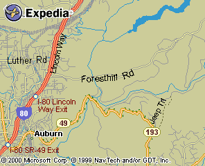
"Once in Forest Hill, take Mosquito Ridge Road to the right. Foresthill, founded in 1850, is an interesting crossroads Gold Rush community with a museum and many historic buildings. It quickly became the central supply location for the surrounding communities. This is the road to Oxbow, Placer County Redwoods, French Meadow and Hell Hole. Along Mosquito Ridge there are several scenic pull-out areas to view the dewatered Horseshoe Bar and Tunnel Chute."
"Descending the road further, you will cross the curved bridge on the North Fork of the Middle Fork. Trails lead upriver and down river from here. There were several mining communities along this tributary to the Middle Fork and the legendary Bogus Thunder Falls are upriver as well."
"Eventually you will cross the curved bridge on the North Fork of the Middle Fork. Continuing on, make a right at the stop sign onto the road to Oxbow Reservoir. The other river you see coming in from the east is the remote and rugged Rubicon. Skirting Oxbow, drop down the dirt road to the graded flat gravel bar put-in area, immediately next to the discharge outlet of the reservoir."
There are several possibilities for take-out on a Middle Fork trip. The two most commonly used by private boaters are the 1) Old Greenwood Bridge crossing site and 2) Mammoth Bar, both on river right. First decide whether you "plan" a one-day or a two-day trip. Keep in mind that some one-day trips unavoidably turn into two-day trips (You know the story, boat wraps or the water is turned off).
Shuttle for take-out at Greenwood Bridge:
"Take the Foresthill Exit off Interstate 80 in Auburn and drive east across the relatively new Auburn-Foresthill Bridge high above the canyons. (Hang gliders and sport parachutists' used to leap from the bridge until it was made illegal.) Continue up Foresthill Road past the ruins of the historic Grizzly Bear House (quartz rock foundation on the right) to Drivers Flat Road turnoff, approximately 4 miles down on the right. This road is paved for the first half-mile, turning into a well graded road the remaining two miles into the canyon. There are scenic views of Cherokee Bar down river and upriver views into lower Ruck-A-Chucky rapids."
"As the road reaches the river you cross a side stream and continue on to the site of the Old Greenwood Bridge (which was washed out in '64 when the uncompleted Hell Hole Dam project broke loose), where there is a rocky area for take-out and put-in. Park your take-out vehicle(s), leave warm clothes, food, flashlights, as it may be late when you return. Return to Foresthill Road the same way. Drivers Flat Road was so named for teamsters who traveled this road on freight wagons with supplies for the many mining camps along the river."
"At the top of Driver's Flat Road, turn right. Then it is about a seven-plus mile drive to the logging town of Foresthill through a thick forest canopy of Black Oak, Incense Cedar, Douglas-fir, Ponderosa Pine and huge Madrone Trees with trunks of reddish-brown bark with green highlights."
Shuttles For Take-out at Mammoth Bar:
"From Highway 49, south of Auburn, descend to the bottom of the canyon, where you go straight from Old Auburn Foresthill Road (instead of right, across the bridge to Cool-Coloma). About 1 and 1/2 miles up the road is a right turn onto a gravel road which leads to Mammoth Bar. Follow the road down to the river and drive all the way to the very upper end past the "free wheeling three-wheeling speed balls and their two-wheeled cousins." Mammoth Bar is an off-road vehicle area. Park your vehicle(s) here and rejoin your friends. The State Parks and Recreation Department has a new gate at the head of this road, which they plan to lock each night and reopen each morning."
For those who desire more information on the Tahoe National Forest, the Foresthill District Headquarters is about one-mile before the town of Foresthill on the right.