South Fork American River Rafting > Mile-by-Mile
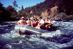
The South Fork of the American is a Class III river. The South Fork offers some of the best whitewater rafting with proximity to the San Francisco Bay Area. The rapids on the South Fork are "rock garden" style rapids: meaning rocks in the channel create the rapids. Large pools follow each rapid, allowing time to regroup after that unexpected, out-of-boat experience. You can raft the upper stretch which puts in at Chili Bar or you can raft the Lower which puts in at either Camp Lotus, Henningson Park, or Marshall State Park. Many of the commercial Whitewater outfitters including All-Outdoors California Whitewater Rafting put-in at Camp Lotus.
 From Chilli Bar Bridge, the river
descends at a steep gradient of 30 feet per mile. The first 5 miles of
rafting are chocked full of exciting Class III whitewater with rapids
like Meatgrinder and Trouble Maker. The next 9 miles descend 9 feet per
mile through the Coloma/Lotus valley and consists of numerous Class II
rapids. The last 5 miles are mostly Class III descending 33 per mile,
with challenging rapids such as Fowlers, Bouncing Rock and Hospital Bar.
From Chilli Bar Bridge, the river
descends at a steep gradient of 30 feet per mile. The first 5 miles of
rafting are chocked full of exciting Class III whitewater with rapids
like Meatgrinder and Trouble Maker. The next 9 miles descend 9 feet per
mile through the Coloma/Lotus valley and consists of numerous Class II
rapids. The last 5 miles are mostly Class III descending 33 per mile,
with challenging rapids such as Fowlers, Bouncing Rock and Hospital Bar.
The following mile-by-mile river map contains the most common names of the rapids. It is not uncommon for boaters to have different names for some of the rapids.
Excerpted from The American River: A Recreational GuidebookPhoto courtesy of All-Outdoors California Whitewater Rafting
Mile By Mile:
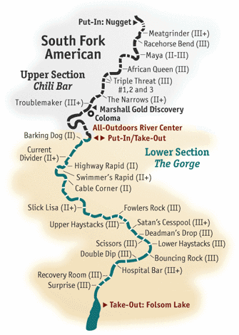 0 Put-In: Chili Bar River Access. Fees charged.
0.6 Meatgrinder Class III+
1.3 Racehorse Bend Class III
1.5 Maya Class II-III.
2.0 African Queen Rapid. Class II.
3.1 Triple Threat Rapid Class III.
Miner's Creek. on river right. is a recommended lunch stop with rest room
facilities.
4.4 Indian Creek enters on river left. Beginning of Quiet zone.
5.2 Troublemaker Rapid. Class III+.
5.2 American River Resort River Access and Campground. Fees charged.
5.5 Coloma Resort River Access and Campground. Fees charged.
5.6 Coloma Bridge. built in 1917.
5.7
Sutter's's Mill site.
6.0 Marshall Gold Discovery State Historic Park - North Beach River Access
Area. Fees charged. Picnic and rest room facilities. Take-outs are prohibited.
7.1 Old Scary Class II.
7.4 Highway 49 Bridge River Access. Parking under bridge is prohibited.
8.0 Henningsen-Lotus County Park River Access (funded by the Dept. of
Boating and Waterways). Fees charged. Upstream and downstream from this
park are small parcels of BLM public lands.
9.0 Camp Lotus River Access and Campground. Fees charged.
9.1 Barking Dog Class II.
10.6 Current Divider Class II+.
11.2 Highway Class II.
11.5 Greenwood Creek on river right. End of the Quiet Zone.
12.0 Cable Corner Class II.
12.2 BLM public land on river right is a recommended lunch/camping area
with rest room facilities.
12.8 There are several lunch/camping sites (no facilities on BLM public
lands between Hastings Creek and mile 13.4.)
15.8 Fowler's Rock Beginning of the Gorge. Class III-
16.2 Upper Haystack Canyon Class III
16.9 Satan's Cesspool Class III+
17.0 Deadman's Drop or Son of Satan's Class II+
17.6 Lower Haystack Canyon Class II+
17.7 BLM land to mile 18.1
18.1 Weber Creek enters on river left at mile
18.2 Bouncing Rock Class II+
18.6 Hospital Bar Class III
18.7 Recovery Room Class II+
19.4 Surprise Rapid. Class III
20.5 Salmon Falls Bridge take-out on the right bank upstream of the bridge.
Parking fees charged.